| This map is found on Mapicurious.com | Download these points of interest directly into your favorite GPS or other geo software | |||
|
|||
| Use the zoom controls on the map to adjust the map's viewable area then print: | |||
| LOCATIONS highlighted on this map: |
|
lat:31.89018 
At Fort McAllister 9/3/2007 [31.89018, -81.19846]
lat:31.89018 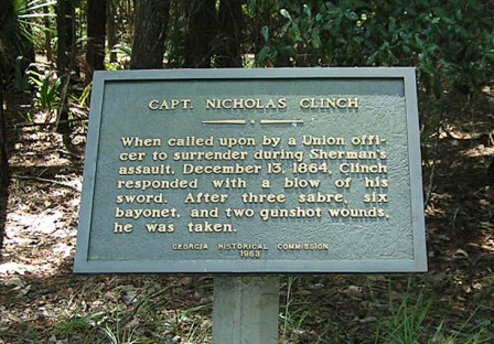
At Fort McAllister 9/3/2007 [31.89018, -81.19846]
lat:31.89157 
At Fort McAllister 9/3/2007 [31.89157, -81.19587]
lat:31.89155 
At Fort McAllister 9/3/2007 [31.89155, -81.19556]
lat:31.89053 
At Fort McAllister 9/3/2007 [31.89053, -81.19593]
lat:31.89157 
At Fort McAllister 9/3/2007 [31.89157, -81.19587]
lat:31.94962 
US 17/GA 25 at GA 144 9/3/2007 [31.94962, -81.31221]
lat:31.88925 
At Fort McAllister 9/3/2007 [31.88925, -81.19953]
lat:31.94962 
US 17 at junction with GA 144, Richmond Hill 9/3/2007 [31.94962, -81.31221]
lat:31.89023 
Intersection of GA 144 and GA 144 Spur, 5.4 mi E of US 17 9/3/2007 [31.89023, -81.261941] The marker si missing. Click on the link to see the marker on the UGA site.
lat:31.89018 
At Fort McAllister 9/3/2007 [31.89018, -81.19846] The marker si missing and is reported to be removed for cleaning. Click on the link to see the marker on the UGA site.
lat:31.89018 
At Fort McAllister 9/3/2007 [31.89018, -81.19846] The marker si missing and is reported to be removed for cleaning. There is no picture available.
lat:31.88304 
On GA 144 Spur, 2.1 miles north of GA 144 9/3/2007 [31.88304, -81.23007]
lat:31.97276 
GA 144, 4.2 miles west of junction with US 17 11/10/2007 [31.97276, -81.37727]
lat:32.19174 
US 80 at the Ogeechee River 11/10/2007 [32.19174, -81.41813]
lat:31.89023 
Intersection of GA 144 and GA 144 Spur, 5.4 mi E of US 17 9/3/2007 [31.89023, -81.261941] The marker si missing. Click on the link to see the marker on the UGA site.
lat:31.88925 
At Fort McAllister 9/3/2007 [31.88925, -81.19953]
lat:31.89155 
At Fort McAllister 9/3/2007 [31.89155, -81.19556]
lat:31.89018 
At Fort McAllister 9/3/2007 [31.89018, -81.19846]
lat:31.89157 
At Fort McAllister 9/3/2007 [31.89157, -81.19587]
lat:31.89157 
At Fort McAllister 9/3/2007 [31.89157, -81.19587]
lat:32.16665 
US 280/GA 30 at Black Creek Church Rd, 3.6 miles W of US 80 9/3/2007 [32.16665, -81.4893]
lat:31.89018 
At Fort McAllister 9/3/2007 [31.89018, -81.19846] The marker si missing and is reported to be removed for cleaning. Click on the link to see the marker on the UGA site.
lat:31.89018 
At Fort McAllister 9/3/2007 [31.89018, -81.19846] |


|
Although the author has taken all reasonable care in preparing this guide, Mapicurious and the author make no warranty about the accuracy or completeness of its content and accept no responsibility for any loss, injury, or inconvenience arising from its use. |