| This map is found on Mapicurious.com | Download these points of interest directly into your favorite GPS or other geo software | |||
|
|||
| Use the zoom controls on the map to adjust the map's viewable area then print: | |||
| LOCATIONS highlighted on this map: |
|
lat:32.87405 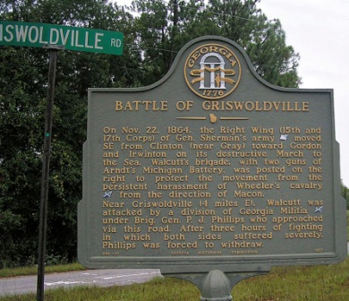
GA 49 at the Bibb County Line 8/31/2007 [32.87405, -83.55549]
lat:32.87108 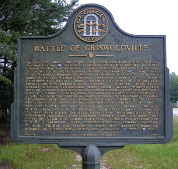
Henderson Road in Griswold 8/31/2007 [32.87108, -83.48896]
lat:32.87108 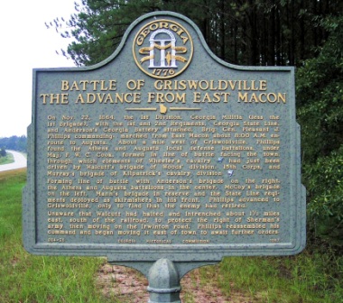
On Henderson Road in Griswold 8/31/2007 [32.87108, -83.48896]
lat:32.86905 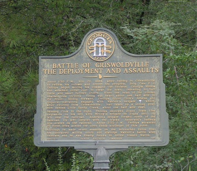
Across the RR tracks one mile east of Griswold 8/31/2007 [32.86905, -83.47311]
lat:32.44957 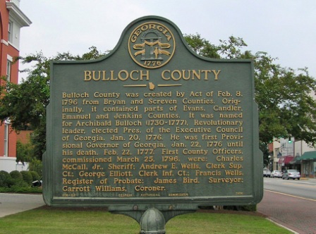
at the courthouse, Statesboro 8/31/2007 [32.44957, -81.78324]
lat:32.87108 
At Old Griswoldville, now Griswold 8/31/2007 [32.87108, -83.48896]
lat:32.87108 
On Henderson Road in Griswold 8/31/2007 [32.87108, -83.48896]
lat:32.54475 
US 80/US 319/US 441 between the Oconee River Bridges, Dublin 8/31/2007 [32.54475, -82.89106]
lat:32.54488 
US 80/US 319/US 441 between the Oconee River Bridges, Dublin 8/31/2007 [32.54488, -82.89120]
lat:32.46153 
US 80/GA 26 in the northwest edge of Statesboro 8/31/2007 [32.46153, -81.79156]
lat:32.44955 
at the courthouse, Statesboro 8/31/2007 [32.44955, -81.78307] |


|
Although the author has taken all reasonable care in preparing this guide, Mapicurious and the author make no warranty about the accuracy or completeness of its content and accept no responsibility for any loss, injury, or inconvenience arising from its use. |