| This map is found on Mapicurious.com | Download these points of interest directly into your favorite GPS or other geo software | |||
|
|||
| Use the zoom controls on the map to adjust the map's viewable area then print: | |||
| LOCATIONS highlighted on this map: |
|
lat:33.87155578708148 Click the link for pictures of Cobb County markers.
lat:33.90623 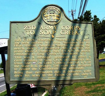
US 41 north of Terrell Mill Rd (8/18/06) [33.90623N, 84.49023W]
lat:33.81302 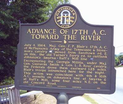
US 78 at Harding Drive (6/19/06) [33.81302N, 84.55972W]
lat:33.84932 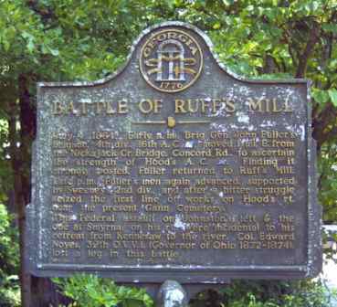
Concord Road just east of Nickajack Creek (6/19/06) [33.84932N, 84.55859W]
lat:33.88295 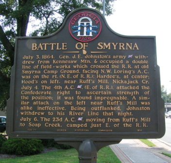
Memorial Park, 2861 Atlanta Road, Smyrna (8/18/06) [33.88295N, 84.51382W]
lat:33.88346 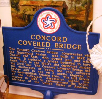
Smyrna Museum, 2861 Atlanta Road, Smyrna (8/18/06) [33.88346N, 84.51408W]
lat:33.84932 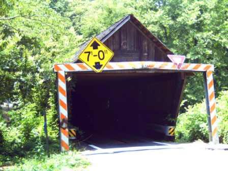
At Ruff's Mill on Concord Road at covered bridge (6/19/06) [33.84932N, 84.55859W]
lat:33.80412 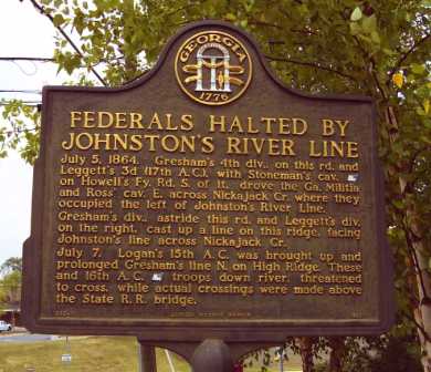
US 78 at ridge west of Nickajack Creek at Queen Mill Rd (6/19/06) [33.80412N, 84.52665W]
lat:33.81255 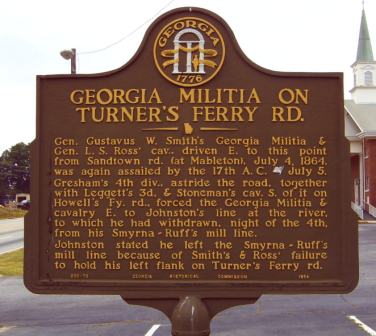
US 78 at Mt Harmony church, 2 mi W of Chattahoochee River (6/19/06) [33.81255N, 84.53783W]
lat:33.86712 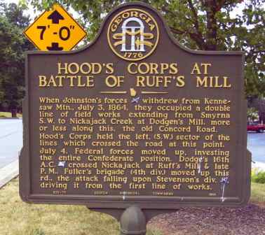
Concord Road at Hurt Road (6/19/06) [33.86712N, 84.53976W]
lat:33.80010 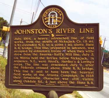
US 78 at Oakdale Rd (6/19/06) [33.80010N, 84.51419W]
lat:33.84467 
Concord Road at Westfield Road (6/19/06) [33.84467N, 84.58080W]
lat:33.870857 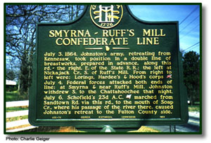
Concord Road and Old Concord Road (6/19/06) [33.870857N, 84.536095W] No marker at this location.
lat:33.84477 
Concord Road at Hicks Road (6/19/06) [33.84477N, 84.57880W]
lat:33.84477
Concord Road at Hicks Road (6/19/06) [33.84477N, 84.57880W]
lat:33.90149 
Cemetery at 2500 Windy Hill Rd between US 41 and I-75 (8/18/06) [33.90149N, 84.48005W]
lat:33.82699 
5239 Floyd Road (at the house), north of Mableton (8/18/06) [33.82699N, 84.57522W]
lat:33.84477 
Concord Rd at Hicks Rd (6/19/06) [33.84477N, 84.57880W] No marker at this location.
lat:33.81123 
GA 139 southeast of Mableton (at Old Alabama Road) (8/18/06) [33.81123N, 84.57178W]
lat:33.84485 
Intersection of Concord Rd and Floyd Rd north of Mableton (6/19/06) [33.84485N, 84.58267W]
lat:33.81231 
GA 139 SE of Mableton at the old Cobb County Branch Library (8/18/06) [33.81231N, 84.57217W
lat:33.81742 
Ga 139 just southeast of US 78 in Mableton (6/19/06) [33.81742N, 84.57559W] |


|
Although the author has taken all reasonable care in preparing this guide, Mapicurious and the author make no warranty about the accuracy or completeness of its content and accept no responsibility for any loss, injury, or inconvenience arising from its use. |