| This map is found on Mapicurious.com | Download these points of interest directly into your favorite GPS or other geo software | |||
|
|||
| Use the zoom controls on the map to adjust the map's viewable area then print: | |||
| LOCATIONS highlighted on this map: |
|
lat:34.015204 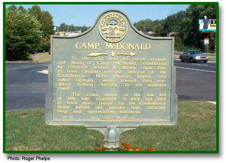
US 41 at old motel near Kennesaw-Due West Rd (10/29/07) [34.015204, -84.615065] Could not locate marker.
lat:33.984130 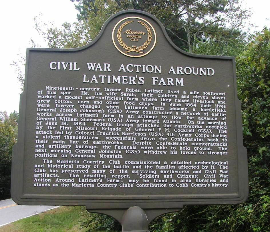
New Salem Rd. just south of Stilesboro Rd. at the Marietta Country Club (10/16/07) [33.984130, -84.61705]
lat:33.97935 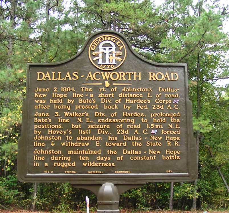
County Line at Burnt Hickory Rd (10/16/07) [33.97935, -84.73476]
lat:33.963442 Burnt Hickory Rd north of Old Mountain Rd intersection (10/29/07) [33.963442, -84.593746] Could not locate marker.
lat:33.97010 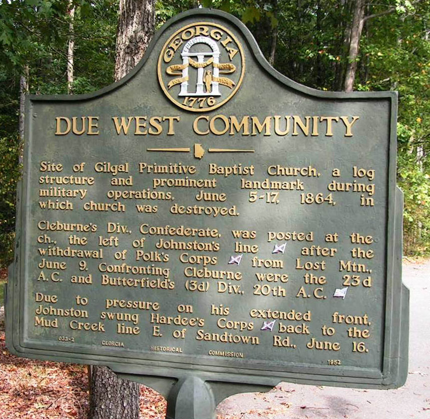
At Gilgal Church on Kennesaw-Due West Rd east of Due West (10/16/07) [33.97010, -84.66366]
lat:34.016157 Acworth-Due West Rd north of Mars Hill Church Rd 10/29/07) [34.016157, -84.67546] Could not locate marker.
lat:34.03720 
Mars Hill Rd SW of US 41 near Mars Hill Church (10/29/07) [34.03720, -84.69241] Could not locate marker.
lat:33.95224 
GA 120 at Casteel Road (10/16/07) [33.95224, -84.66271]
lat:33.97227 
New Salem Rd between Stilesboro and Burnt Hickory Rds (10/16/07) [33.97227, -84.61712]
lat:33.853565 
GA 3 (Marietta Rd) at Log Cabin Rd
lat:33.97950 
Due West Road at County Line Road (10/16/07) [33.97950, -84.73515]
lat:33.99847 
Burnt Hickory Rd at County Line Rd (10/16/07) [33.99847, -84.72923]
lat:33.94077 
Ga 120 at Ga 176 junction at Lost Mountain community (10/16/07) [33.94077, -84.70305]
lat:33.99397 
Stilesboro Rd opposite Pine Mountain Circle (10/29/07) [33.99397, -84.63809]
lat:34.03359 
Mars Hill Church Rd at Rose Arbor Dr. NW (10/29/07) [34.03359, -84.68897]
lat:33.9022 
Chattahoochee Recreation Area parking area at I-285 & river
lat:34.01286 
Acworth-Due West Rd at Old Stilesboro Rd (10/29/07) [34.01286, -84.67592]
lat:33.8668 
At the house on Paces Mill Road, Vinings
lat:33.99820 
Stilesboro Rd at Acworth-Due West Rd (10/29/07) [33.99820, -84.67549]
lat:34.01118 
GA 293 (Old US 41) about 1 mile south of Kennesaw (10/16/07) [34.01118, -84.60670]
lat:33.87001 
US 41 just north of Chattahoochee River
lat:33.85688 
South Cobb Drive (GA 280) S of King's Spring Rd at Emory Hospital
lat:33.84183340883619 
GA 3 (Marietta Rd) at south side of I-285 interchange
lat:33.95965 
GA 120 (Roswell Rd) just west of Loop 120 junction Marker reported missing. This picture from UGA. Could not confirm GPS. 33.95965, -84.49774)
lat:33.9022 
Chattahoochee Recreation Area parking area at I-285 & river
|


|
Although the author has taken all reasonable care in preparing this guide, Mapicurious and the author make no warranty about the accuracy or completeness of its content and accept no responsibility for any loss, injury, or inconvenience arising from its use. |