| This map is found on Mapicurious.com | Download these points of interest directly into your favorite GPS or other geo software | |||
|
|||
| Use the zoom controls on the map to adjust the map's viewable area then print: | |||
| LOCATIONS highlighted on this map: |
|
lat:33.751022 Click on the link to visit 11 pages of pictures.
lat:33.80671 
lat:33.746529 
Memorial Drive and Stovall Street, Atlanta 8/11/05) [33.746529N, 84.354398W]
lat:33.753971 
Boulevard Drive at Walthall St, Atlanta (8/11/05) [33.753971N, 84.351632W]
lat:34.00148 
On the walking path west of Roswell Rd. and Azalea
lat:33.7717 
lat:33.77902 
Marker missing. A new complex has been built on this location.
lat:33.70872 
lat:33.730160 
Grant Park, Boulevard and Atlanta Ave, Atlanta (8/11/05) [33.730160N, 84.368340W]
lat:33.8036 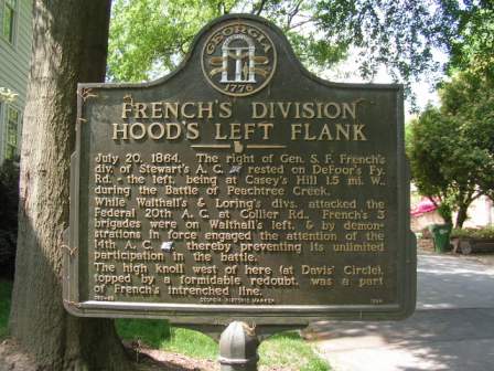
lat:33.736616 
Cherokee Ave and Georgia Ave at park entrance, Atlanta (8/11/05) [33.736616N, 84.373660W]
lat:34.00518 
On the walking path near
lat:33.824274
This marker is missing.
lat:33.83850 
Marker missing
lat:33.8053 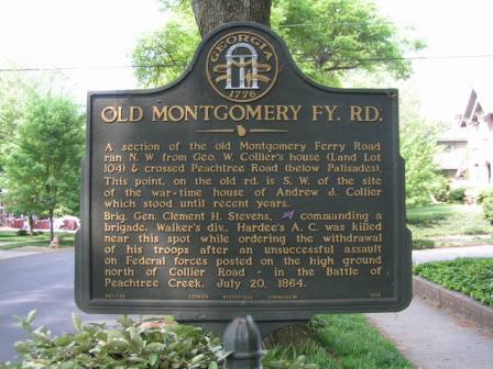
lat:33.85968 
lat:34.00564 
On the walking path near
lat:33.72535 
lat:33.7795 
lat:33.82555 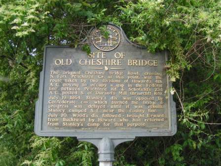
lat:33.77156 
Marker missing.
lat:33.85844 
Lovett School on road east of traffic circle (05/26/06) [33.85844N, 84.45042W]
lat:33.83522 
lat:33.76300 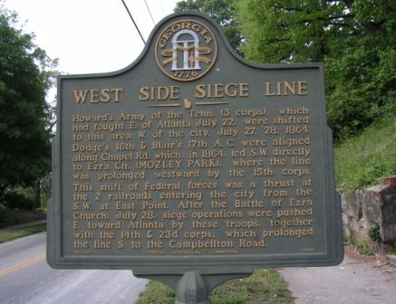
|


|
Although the author has taken all reasonable care in preparing this guide, Mapicurious and the author make no warranty about the accuracy or completeness of its content and accept no responsibility for any loss, injury, or inconvenience arising from its use. |