| This map is found on Mapicurious.com | Download these points of interest directly into your favorite GPS or other geo software | |||
|
|||
| Use the zoom controls on the map to adjust the map's viewable area then print: | |||
| LOCATIONS highlighted on this map: |
|
lat:33.751022 Click on the link to visit 11 pages of pictures.
lat:33.808599 
far west edge of Crest Lawn Cemetery, enter through main gate on Marietta Blvd
lat:33.804907 
Palisades Road near Peachtree Road, Atlanta (12/22/04) [33.804907N, 84.393045W]
lat:33.752805 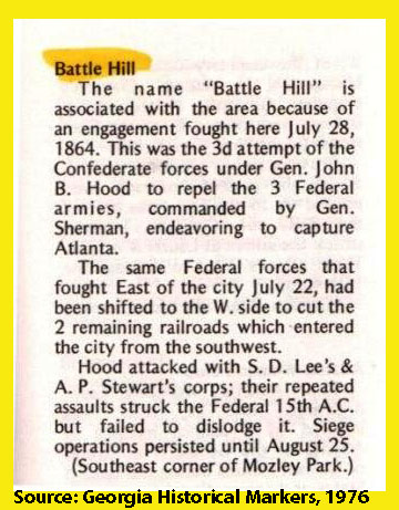
Mozley Park, Martin Luther King Drive, Atlanta (1/6/05) [33.752805N, 84.439179W]
lat:33.750257 
Martin Luther King Drive west of Helena Street (I-20 exit), Atlanta (1/7/05) [33.750257N, 84.448902W]
lat:33.807137 
Brighton Rd at Peachtree Rd, Atlanta in Piedmont Hospital Park. (1/28/05) [33.807137N, 84.394023W]
lat:33.720001 
Cascade Avenue just west of Woodland Terrace, Atlanta (4/27/05) [33.720001N, 84.473332W]
lat:33.810001 
far west edge of Crest Lawn Cemetery, enter through main gate on Marietta Blvd
lat:33.748611 
Elixir at Wellington Streets, Atlanta (5/11/2005) [33.748611N, 84.438340W]
lat:33.922688 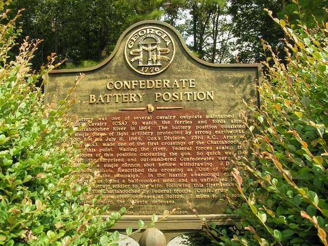
Cul de sac at end of River Chase Point, Sandy Springs (8/17/2004) [33.922688N, 84.428153W]
lat:33.711680 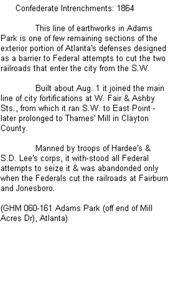
Adams Park (off end of Mill Acres Dr), Atlanta (5/11/2005) [33.711680N, 84.466693W] [could not find]
lat:33.738042 
Fairburn Rd north of Cascade Rd and Utoy Creek
lat:33.788041 
Johnson Rd just west of Perry Blvd and Marietta Rd, Atlanta
lat:33.704459 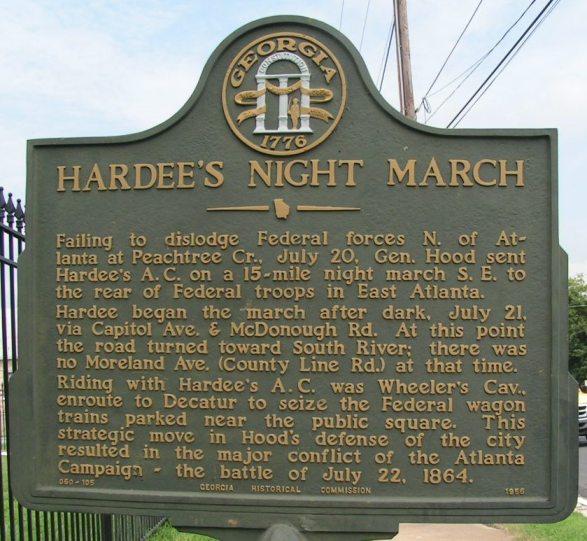
McDonough Rd just west of Moreland Ave, Atlanta (8/11/05) [33.704459N, 84.350839N]
lat:33.753609 
1116 Boulevard Drive, Atlanta (8/11/05) [33.753609N, 84.350547W]
lat:33.921112 
Heard family cemetery, end of Heards Drive, Sandy Springs (5/5/05) [33.921112N, 84.422217W]
lat:34.018889 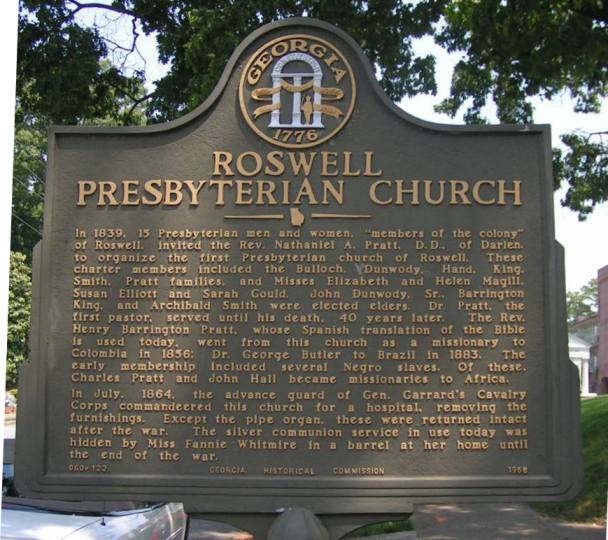
At the church on Mimosa Boulevard, Roswell (05/9/05) [34.018889N, 84.363338W]
lat:33.704377 
1075 McDonough Rd 2 blocks west of Moreland Ave, Atlanta (8/11/05) [33.704377N, 84.352791W]
lat:33.723052 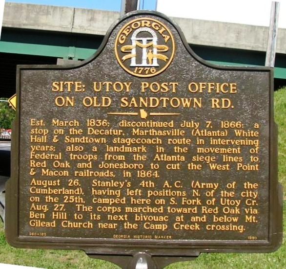
Cascade Rd at east side of I-285 junction (4/27/05) [33.723052N, 84.502256W]
lat:33.719709 
Cascade Ave between Dodson Rd and Woodland Terrace, Atlanta (4/27/05) [33.719709N, 84.473618W]
lat:33.738891 
Cascade Ave at Ralph Abernathy Dr, Atlanta (5/5/2005) [33.738891N, 84.433055W]
lat:34.015284 
Sloan and Mill Streets, Roswell (04/11/05) [34.015284N, 84.361400W]
lat:33.922500 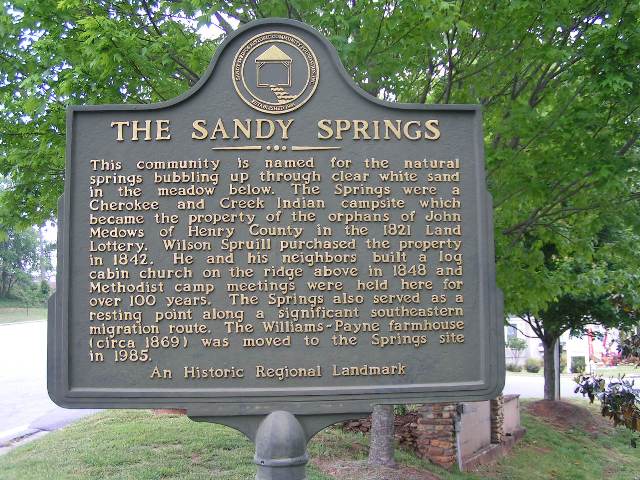
Sandy Springs Circle at Hilderbrand Dr, Sandy Springs (05/5/05) [33.922500N, 84.383057W]
lat:33.750278 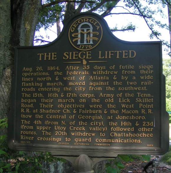
Martin Luther King Dr near Larchwood Road, Atlanta (5/11/2005) [33.750278N, 84.456671W ]
lat:33.739166 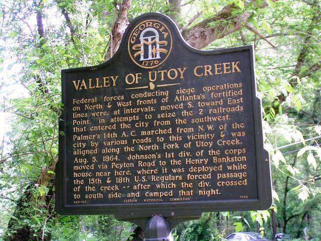
Peyton Rd at bridge over North Fork of Utoy Creek, Atlanta (5/5/2005) [33.739166N, 84.478887W] |


|
Although the author has taken all reasonable care in preparing this guide, Mapicurious and the author make no warranty about the accuracy or completeness of its content and accept no responsibility for any loss, injury, or inconvenience arising from its use. |