| This map is found on Mapicurious.com | Download these points of interest directly into your favorite GPS or other geo software | |||
|
|||
| Use the zoom controls on the map to adjust the map's viewable area then print: | |||
| LOCATIONS highlighted on this map: |
|
lat:34.579235082930815 Click the link for pictures of Gordon County markers.
lat:34.603625 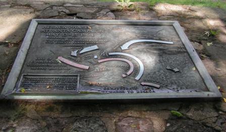
USDI Pavillion on US 41 at road to Resaca Confederate Cemetery (5/17/05) [34.603625N, 84.948916W]
lat:34.58037 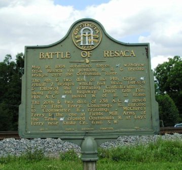
US 41 and GA 136 in Resaca, just north of Resaca Fire Dept. (5/11/06) [34.58037N, 84.94318W]
lat:34.574673 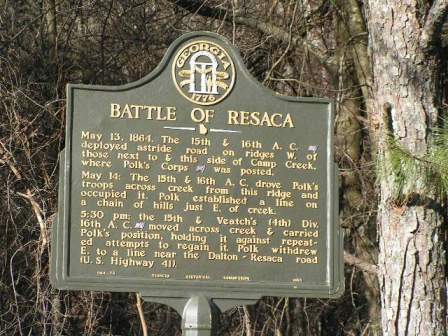
GA 136 at Fain Brown Rd, west of I-75 (1/17/05) [34.574673N, 84.962540W]
lat:34.60582 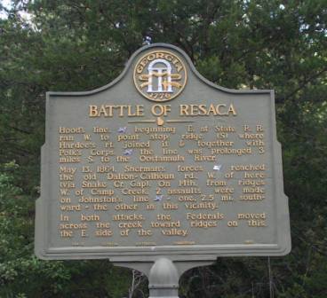
West of US 41 0.4 miles on Rooker Rd, north of Resaca (5/11/06) [34.60582N, 84.95544W]
lat:34.57117 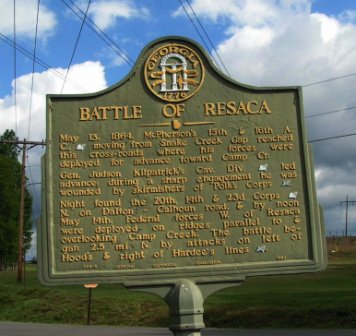
At Hall Memorial and Hall Rd just S of GA 136 W of Resaca (5/11/06) [34.57117N, 84.97376W]
lat:34.61462 
On Chitwood Road, .75 mile east of US 41 5/11/06) [34.61462N, 84.93983W]
lat:34.563570 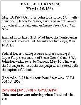
southbound on I-75 in Rest Area 35 south of GA 136 exit (5/17/05) [34.563570N, 84.944163W] Marker missing
lat:34.610556 
Chitwood Rd at US 41 (5/11/06) [34.610556N, 84.951356W]
lat:34.610556 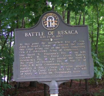
Chitwood Rd at US 41 (5/11/06) [34.610556N, 84.951356W]
lat:34.61229 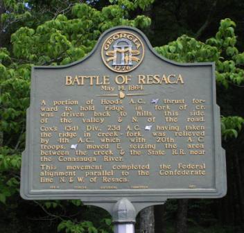
On Chitwood Rd .3 mile east of US 41(5/11/06) [34.61229N, 84.94657W]
lat:34.603734 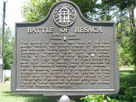
US 41 at Confederate Cemetery Road north of Resaca (5/17/05) [34.603734N, 84.948928W]
lat:34.603734
US 41 at Confederate Cemetery Road north of Resaca (5/17/05) [34.603734N, 84.948928W]
lat:34.605540 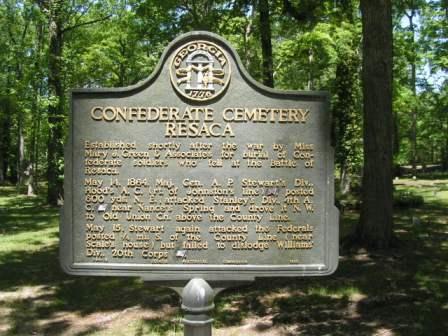
Cemetery 2 miles north of Resaca and east of US 41 (5/17/05) [34.605540N, 84.943875W]
lat:34.58081 
GA 225 at Pine Chapel Rd (3 mi north of Coosawatee River) (5/11/06) [34.58081N, 84.87961W]
lat:34.575241 
West of Resaca on Ga 136 just west of I-75 interchange (1/17/05) [34.575241N, 84.961237W]
lat:34.608740 
GA 136, 7 miles west of I-75, just north of junction of Ga. 136 and Ga. 136C (1/17/05) [34.608740N, 85.045634W] |


|
Although the author has taken all reasonable care in preparing this guide, Mapicurious and the author make no warranty about the accuracy or completeness of its content and accept no responsibility for any loss, injury, or inconvenience arising from its use. |