| This map is found on Mapicurious.com | Download these points of interest directly into your favorite GPS or other geo software | |||
|
|||
| Use the zoom controls on the map to adjust the map's viewable area then print: | |||
| LOCATIONS highlighted on this map: |
|
lat:33.950683 Click the link for pictures of Cobb County markers.
lat:33.9458667 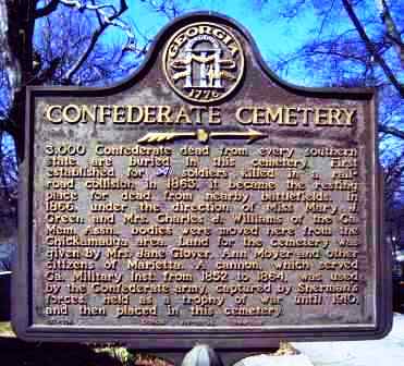
lat:33.94685 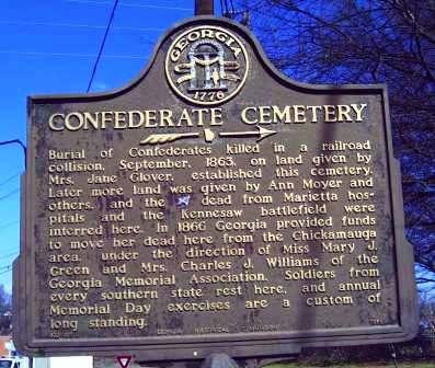
lat:33.96315 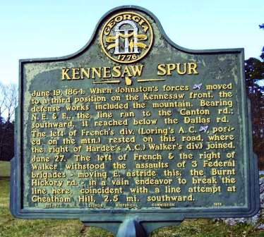
June 19, 1864. When Johnston's forces [CS] moved to a third position on the Kennesaw front, the defense works included the mountain. Bearing N.E. & E., the line ran to the Canton rd.; southward, it reached below the Dallas rd. The left of French's div. (Loring's A.C. [CS], posted on the mtn.) rested on this road, where the right of Hardee's A.C. (Walker's div.) joined. June 27. The left of French & the right of Walker withstood the assaults of 3 Federal brigades -- moving E. astride this, the Burnt Hickory rd. -- in a vain endeavor to break the line here, coincident with a line attempt at Cheatham Hill, 2.5 mi. southward.033-53 GEORGIA HISTORICAL COMMISSION 1954
lat:33.9634667 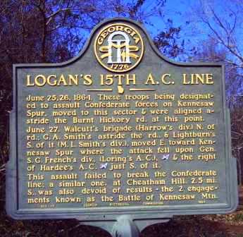
June 25, 1864. These troops being designated to assault Confederate forces on Kennesaw Spur, moved to this sector & were aligned astride the Burnt Hickory rd. at this point.June 27. Walcutt's brigade (Harrow's div.) N. of rd.; G.A. Smith's div.), moved E. toward Kennesaw Spur where the attack fell upon Gen. S.G. French's div., (Loring's A.C.), [CS] & the right of Hardee's A.C. [CS] just S. of it. This assault failed to break the Confederate line; a similar one, at Cheatham Hill, 2.5 mi. S., was also devoid of results -- the 2 engagements known as the Battle of Kennesaw Mtn.033-19 GEORGIA HISTORICAL COMMISSION 1954
lat:33.9334167 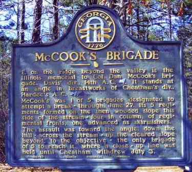
E. on the ridge beyond the valley is the Illinois memorial to Col. Dan McCook's brigade. Davis' div., 14th A. C. [US]. It stands at an angle in breastworks of Cheatham's div., Hardee's A. C. [CS].McCook's was 1 of 5 brigades designated to attempt a break-through, June 27. Its 5 regiments formed on the then wooded slope this side of the stream -- four in column, of regimental fronts, one advanced as skirmishers. The assault was toward the angle down the hill -- across the stream -- up the cleared slope beyond, to the objective -- the only brigade of 5 to reach it, where a close-up line was held until Cheatham withdrew July 3.033-57 GEORGIA HISTORICAL COMMISSION 1954
lat:33.9542167 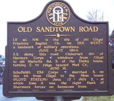
1.5 Mi. N.W. is the site of old Gilgal Primitive Baptist Ch. (at DUE WEST) -- a landmark of military operations. JUNE 5-17, 1864.S.E. along this road Cleburne's div. of Hardee's Corps [CS] withdrew from Gilgal to old Marietta Rd. S. of the Darby house, turning E. to ridge beyond Mud Cr.,JUNE 16.Schofield's 23d Corps [US] marched S. on this rd. from Gilgal to the Moss house (FLOYD STATION) June 17 - July 2, -- at which time it was the right flank of Sherman's forces on Kennesaw front. 033-4 GEORGIA HISTORICAL COMMISSION 1952
lat:33.98475 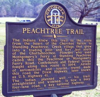
The Indians knew this trail as the route from the heart of the Cherokee Nation to Standing Peachtree, Creek village that grew into a trading post and fort just south of the Chattahoochee. Pioneers who used Montgomery's Ferry at Standing Peachtree called this the Peachtree or Montgomery Ferry Road. Confederate and Federal troops fought along this route in 1864. Advent of automobiles and tourist travel made this road the Dixie Highway, later known as U.S. Highway 41.The Indian planned well -- his trail straightened and widened, is now a busy four-lane road, a key national highway.033-112 GEORGIA HISTORICAL COMMISSION 1959
lat:33.963214 Trail off Burnt Hickory Rd at Old Mountain Rd (2/17/05) 33.963214, -84.593458
lat:33.90518589980856 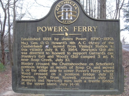
Photographed by Brad Gilreath
lat:33.8849833 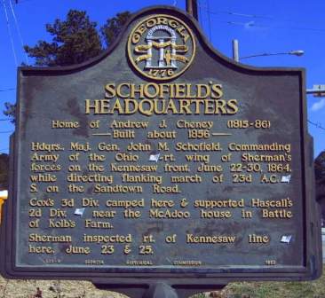
Home of Andrew J. Cheney (1815-86)-- Built about 1856 -- Hdqrs., Maj. Gen. John M. Schofield, Commanding Army of the Ohio [US] -- rt. wing of Sherman's forces on the Kennesaw front, June 22-30, 1864, while directing flanking march of 23d A.C. [US] S. on the Sandtown Road. Cox's 3d Div. camped here & supported Hascall's 2d Div. [US] near the McAdoo house in Battle of Kolb's Farm. Sherman inspected rt. of Kennesaw line [US] here, June 23 & 25. 033-9 GEORGIA HISTORICAL COMMISSION 1952
lat:33.933405 Cheatham Hill Rd just east of John Ward Rd in the parking area (3/10/05) 33.933405, -84.604756
lat:34.0238 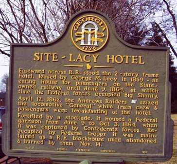
Eastward across R. R. stood the 2-story frame hotel, leased by George M. Lacy in 1859 -- an eating house for passengers on the State-owned railway until June 9, 1864, at which time the Federal forces occupied Big Shanty.April 12, 1862, the Andrews Raiders [US] seized the locomotive "General" while train crew & passengers were breakfasting at the hotel.Fortified by a stockade, it housed a Federal garrison from June 9 to Oct. 3, 1864, when it was recaptured by Confederate forces. Reoccupied by Federal troops it was maintained as a R. R. blockhouse until abandoned & burned by them, Nov. 14.033-41 GEORGIA HISTORIC MARKER 1954
lat:33.93805 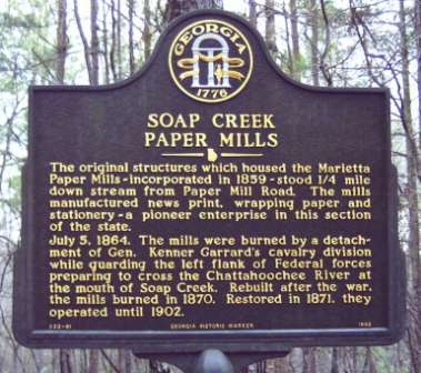
lat:33.93805 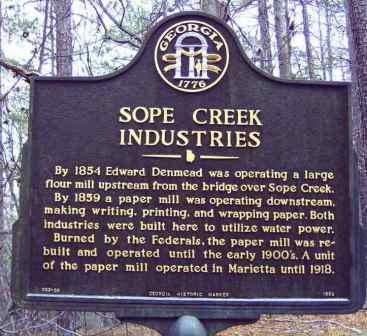
By 1854 Edward Denmead was operating a large flour mill upstream from the bridge over Sope Creek.By 1859 a paper mill was operating downstream, making writing, printing, and wrapping paper. Both industries were built here to utilize water power.Burned by the Federals, the paper mill was rebuilt and operated until the early 1900's. A unit of the paper mill operated in Marietta until 1918.033-36 GEORGIA HISTORIC MARKER 1992
lat:34.0238 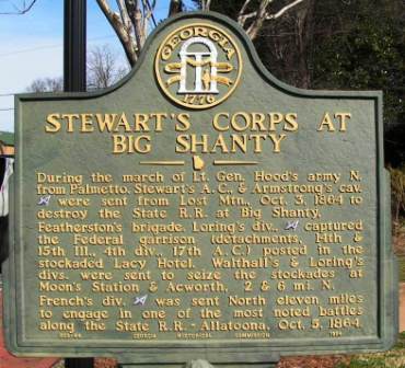
During the march of Lt. Gen. Hood's army N. from Palmetto, Stewart's A. C., & Armstrong's cav. [CS] were sent from Lost Mtn., Oct. 3, 1864 to destroy the State R. R. at Big Shanty.Featherston's brigade, Loring's div., [CS] captured the Federal garrison (detachments, 14th & 15th Ill., 4th div., 17th A. C.) posted in the stockaded Lacy Hotel. Walthall's & Loring's divs. were sent to seize the stockades at Moon's Station & Acworth, 2 & 6 mi. N. French's div. [CS] was sent North eleven miles to engage in one of the most noted battles along the State R. R. - Allatoona, Oct. 5, 1864033-44 GEORGIA HISTORICAL COMMISSION 1954
lat:33.85968 
lat:33.93805 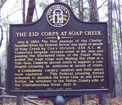
July 8, 1864. The first passage of the Chattahoochee River by Federal forces was made at mouth of Soap Creek by Cox's division, 23d A.C. [US]. Cameron's brigade crossed creek at the dam and passing the blackened ruins of the Paper Mills, scaled the high ridge east. Wading the river at a fish-dam, Cameron moved south to support a contingent crossing in pontoons at mouth of creek. A Confederate cavalry outpost and field-piece were captured. This Federal crossing forced Johnston to abandon his River Line at and below Bolton; he withdrew to the Fulton County side of the Chattahoochee River, July 9.033-92 GEORGIA HISTORIC MARKER 1992
lat:33.86600 
lat:33.870808 
Photo courtesy: Brad Gilreath
lat:34.0238 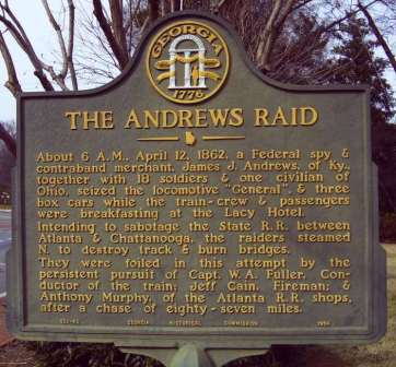
About 6 A.M., April 12, 1862, a Federal spy & contraband merchant, James J. Andrews, of Ky., together with 18 soldiers & one civilian of Ohio, seized the locomotive "General", & three box cars while the train-crew & passengers were breakfasting at the Lacy Hotel.Intending to sabotage the State R. R. between Atlanta & Chattanooga, the raiders steamed N. to destroy track & burn bridges.They were foiled in this attempt by the persistent pursuit of Capt. W. A. Fuller, Conductor of the train: Jeff Cain, Fireman; & Anthony Murphy, of the Atlanta R. R. shops, after a chase of eight-seven miles.033-42 GEORGIA HISTORICAL COMMISSION 1954
lat:34.023812 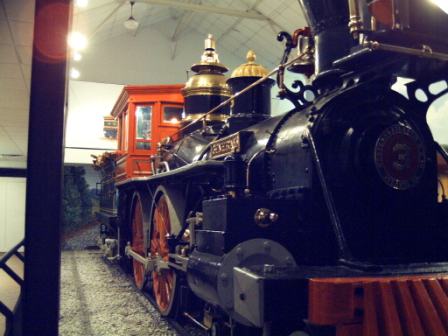
The General At the Museum on Cherokee St (off Ga 293 (Old US 41)) in Kennesaw
lat:33.85960 
lat:33.904616008362325 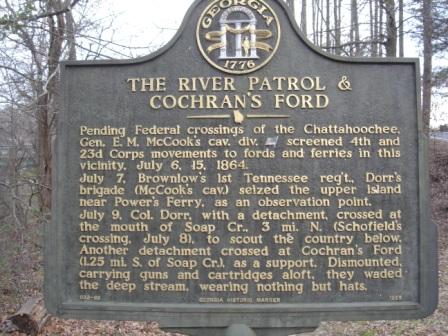
Photographed by Brad Gilreath |


|
Although the author has taken all reasonable care in preparing this guide, Mapicurious and the author make no warranty about the accuracy or completeness of its content and accept no responsibility for any loss, injury, or inconvenience arising from its use. |