| This map is found on Mapicurious.com | Download these points of interest directly into your favorite GPS or other geo software | |||
|
|||
| Use the zoom controls on the map to adjust the map's viewable area then print: | |||
| LOCATIONS highlighted on this map: |
|
lat:33.775662 Click the link for pictures of DeKalb County markers.
lat:33.854449 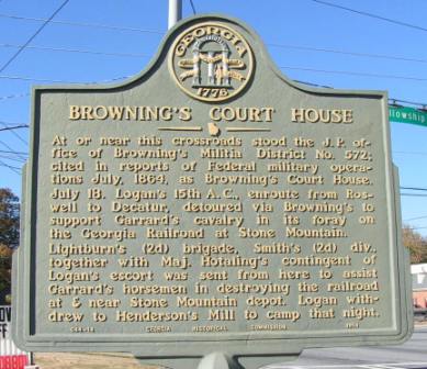
lat:33.8967833 
lat:33.843152 
lat:33.91696 
Buford Highway at English Oak Dr, at Gwinnett County line
lat:33.790833 
lat:33.88101 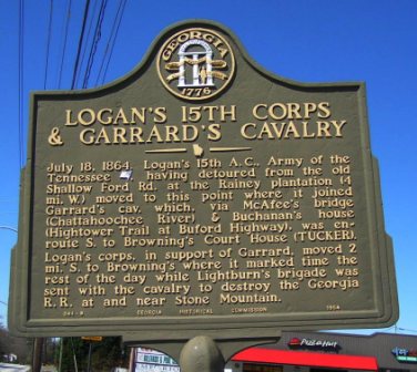
Chamblee-Tucker Rd just west of Pleasantdale Road (3/14/06)
lat:33.851847 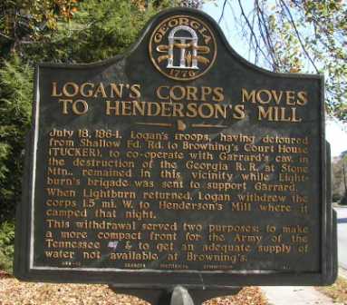
lat:33.86005 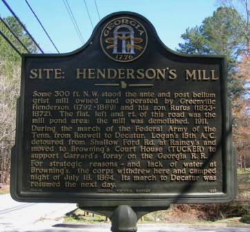
Henderson Mill Rd south of Midvale Rd, S of crk at St Bede's Episcopal Church parking lot.
lat:33.790578 
lat:33.796817 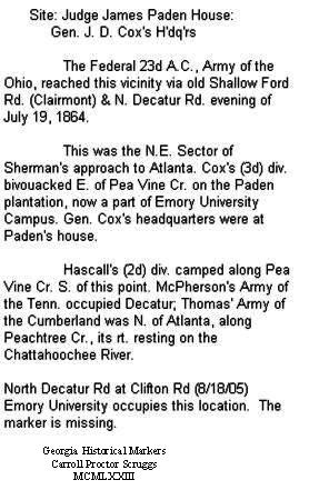
Emory University occupies this location. The marker is missing.
lat:33.85780 
Peachtree Rd SW of North Druid Hills Rd intersection
lat:33.77553 
Just off US 278 & Avondale Road on Berkeley Rd. in Avondale Estates (3/15/06)
lat:33.72281 
US 278 at Panola Rd, at Belmont (3/15/06)
lat:33.76035 
Norris Lake Rd at Norris Lake Dr (at Norris Lake) South of GA 124 (Centerville Hwy.)
lat:33.78730 
N. Stone Mountain Lithonia Road at Rockbridge Road
lat:33.87568 
Peachtree Rd at Ashford Dunwoody Rd (3/14/06)
lat:33.8118833 
lat:33.7532 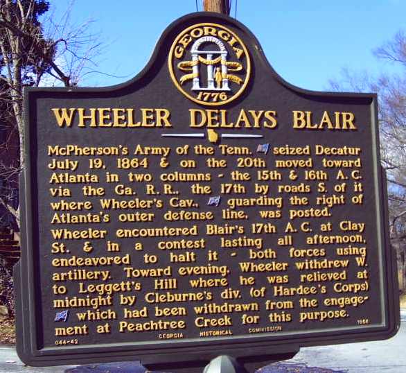
lat:33.7450167 
July 20, 1864. Wheeler's thin gray line of dismounted cavalry [CSA] was the rt. flank of Atlanta's defenders. Forced W. from Clay St. in the afternoon by Blair's 17th A.C., [Union] Wheeler's line ran S. from the Ga. R.R. to this hill.July 21. Before dawn, Wheeler was replaced by Cleburne's div. (Hardee's A.C.) [CSA] which was shifted from Peachtree Cr. battlefield to meet the advance of the Federals from Decatur.Blair's 17th A.C., resuming the offensive, made its main attack upon the hill. Leggett's div. of the 17th, forced Cleburne's withdrawal -- thereby gaining a point on Atlanta's outer defenses -- the eminence known as Leggett's Hill044-66 GEORGIA HISTORICAL COMMISSION 1956
lat:33.84232 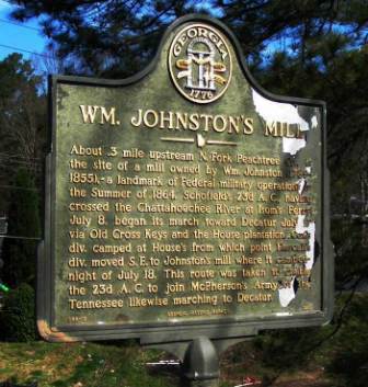
Briarwood Rd SE of Buford Hwy at North Fork, Peachtree Creek (3/14/06) |


|
Although the author has taken all reasonable care in preparing this guide, Mapicurious and the author make no warranty about the accuracy or completeness of its content and accept no responsibility for any loss, injury, or inconvenience arising from its use. |