| This map is found on Mapicurious.com | Download these points of interest directly into your favorite GPS or other geo software | |||
|
|||
| Use the zoom controls on the map to adjust the map's viewable area then print: | |||
| LOCATIONS highlighted on this map: |
|
lat:35.888889 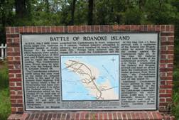
NC 345 S. of US 64/264 in Manteo (8/30/05) [35.888889, -75.660278]
lat:35.220000 
NC 12 N. in Hatteras at North End Rd. (8/31/05) [35.220000, -75.690000]
lat:35.207500 
Fort Hatters and Fort Clark, 2 miles S.W. fell to Union troops on Aug.29, 1861, after two days of heavy naval bombardment. Marker blown away by hurricane. NC 12 at Hatteras ferry landing (8/30/05) [35.207500, -75.702222]
lat:35.595556 
NC 12 N. of Rodanthe at Midgett Rd. (8/31/05) [35.595556, -75.467778]
lat:35.936549 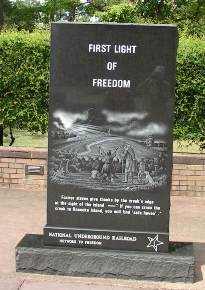
At Fort Raleigh National Historical Site US 62/264 in Manteo (8/30/05) [35.936549, -75.709415]
lat:35.511667 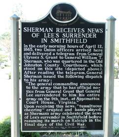
Market and 2nd St. at the Court House, Smithfield (9/3/05) [35.511667, -78.347222]
lat:35.276944 
US 301 S. of Dunn at Long Branch Rd Page updated on September 7, 2005
lat:35.500000 
US 301/NC 96 (3rd St) at Brogden Rd., Smithfield (9/3/05) [35.500000, -78.350833]
lat:35.669722 
Main St. (US 70) between Liberty and Kerr, Salisbury (8/27/05) [35.669722, -80.466944]
lat:35.533611 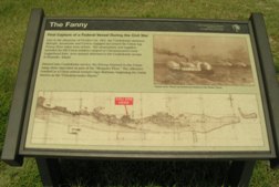
NC 12 S. of Salvo (9/3/05) [35.533611, -75.475556]
lat:35.42771 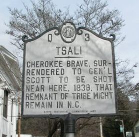
US 19 (Main St. at Everett) Bryson City NC by Old Court House (2/16/08) [35.42771, -83.44485]
lat:35.265833 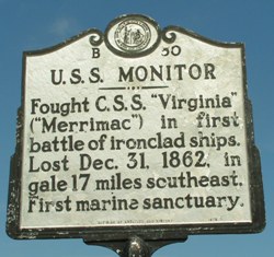
U.S.S. Monitor B-50 NC 12 N. of Buxton (8/31/05) [35.265833, -75.520556] |


|
Although the author has taken all reasonable care in preparing this guide, Mapicurious and the author make no warranty about the accuracy or completeness of its content and accept no responsibility for any loss, injury, or inconvenience arising from its use. |