| This map is found on Mapicurious.com | Download these points of interest directly into your favorite GPS or other geo software | |||
|
|||
| Use the zoom controls on the map to adjust the map's viewable area then print: | |||
| LOCATIONS highlighted on this map: |
|
lat:33.75431694675655
lat:33.749009 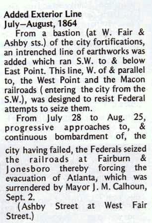
Ashby St at West Fair St, Atlanta (Joseph E Lowery Blvd SW & Fair St SW, Atlanta, GA 30314) 10/30/2008 [33.749009° -84.417458°] I have visited this location several times and have been unable to locate the marker. Morehouse College has a new building at this location
lat:33.76672 
Carter Presidential Center South parking lot (6/25/08) [33.76672 -84.35576]
lat:33.76691 
Carter Presidential Center South parking lot (6/25/08) [33.76691, -84.35565]
lat:33.75560 
Edgewood Ave and Delta Place, Atlanta (6/25/08) [33.75560, -84.35929]
lat:33.77471 
Briarcliff Rd between St Charles Pl and St Augustine Pl, Atl (marker missing) (6/25/08) [33.77471, -84.34901]
lat:33.76968 
Ralph McGill Blvd just west of Linwood St, Atlanta (6/25/08) [33.76968, -84.35676]
lat:33.79167 
Dutch Valley Rd at Monroe Dr, Atlanta (6/25/08) [33.79167, -84.36724]
lat:33.750869° 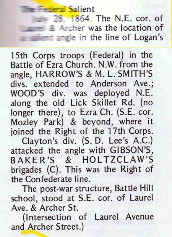
Laurel Ave and Archer St, Atlanta 10/30/2008 [33.750869° -84.440138°] There is no marker at this location. |


|
Although the author has taken all reasonable care in preparing this guide, Mapicurious and the author make no warranty about the accuracy or completeness of its content and accept no responsibility for any loss, injury, or inconvenience arising from its use. |