| This map is found on Mapicurious.com | Download these points of interest directly into your favorite GPS or other geo software | |||
|
|||
| Use the zoom controls on the map to adjust the map's viewable area then print: | |||
| LOCATIONS highlighted on this map: |
|
lat:35.59157 
lat:35.74832 
lat:34.98808 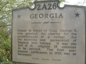
Named in honor of King George II, who granted the charter for the establishment of a refuge for the destitute and persecuted of England and Europe. It was the last of the original 13 colonies to be settled. The first permanent settlement, in 1733, was at Savannah.
lat:35.75503 
lat:35.75238 
lat:35.16478 
lat:35.75392 
lat:35.75177 
lat:35.75188 
lat:35.66842 
lat:35.59143 
lat:35.75368 
|


|
Although the author has taken all reasonable care in preparing this guide, Mapicurious and the author make no warranty about the accuracy or completeness of its content and accept no responsibility for any loss, injury, or inconvenience arising from its use. |