| This map is found on Mapicurious.com | Download these points of interest directly into your favorite GPS or other geo software | |||
|
|||
| Use the zoom controls on the map to adjust the map's viewable area then print: | |||
| LOCATIONS highlighted on this map: |
|
lat:34.709103 Click the link for five pages of pictures including Walker County.
lat:34.7458333 Ga 95, 0.4 mile southeast of Catlett [34.7458333N, -85.1858333W]
lat:34.7152778 behind city fence on Indiana St. several blocks west of N. Main St./US 27 Bus north of downtown LaFayette [34.7152778N, -85.2880556W]
lat:34.7086111 in park several blocks north of downtown on N. Main St. in LaFayette [34.7086111N, -85.2811111W]
lat:34.7452778 in trees on Ga 151 across from intersection with Cooper Rd, 1.2 miles northeast of junction with Ga 95 [34.7452778N, -85.1661111W]
lat:34.7086111 in park several blocks north of downtown on N. Main St. in LaFayette [34.7086111N, -85.2811111W]
lat:34.9813889 at historic house on Spring Street two blocks west of US 27 in Rossville [34.9813889N, -85.285W]
lat:34.8830556 inside fence at the restored Lee and Gordon's Mill across from intersection of Lee and Gordon's Mill Rd. and Red Belt Rd., two blocks east of US 27 in Chickamauga [34.8830556N, -85.2677778W]
lat:34.752513 
lat:34.6747222 
lat:34.9838889 in park at junction of US 27 and McFarland and Gordon Streets in Rossville [34.9838889N, -85.2863889W]
lat:34.8205556 on Old US 27 just west of the post office at the junction of US 27 and Ga 95 near Chickamauga [34.8205556N, -85.2416667W]
lat:34.956858 on Lee and Gordon Mill Rd. at railroad crossing by city hall in Chickamauga
lat:34.6980556 
lat:34.728420 in park several blocks north of downtown on N. Main St. (GA 1) in LaFayette
lat:34.7086111 in park several blocks north of downtown on N. Main St. in LaFayette [34.7086111N, -85.2811111W]
lat:34.6738889 
lat:34.7086111 
Created December 18, 1833, and named for Major Freeman Walker of Augusta, prominent attorney and United States Senator. Here the fierce Chickamaugas preyed upon pioneers, and were in turn defeated and drive away; here Federals and Confederates locked in combat in 1863.Lookout Mountain and its spur Pigeon Mountain on the West, Taylor's and Dick's Ridges on the east of the county provide spectacular scenery. Rich coal and iron deposits abound; between the mountains lie fertile valleys.146-3 GEORGIA HISTORICAL COMMISSION 1953
lat:34.6805556 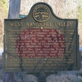
|


|
Although the author has taken all reasonable care in preparing this guide, Mapicurious and the author make no warranty about the accuracy or completeness of its content and accept no responsibility for any loss, injury, or inconvenience arising from its use. |